

India has to invest long-term in infrastructure along the Indo-China border
Palak Gupta
The scuffle in the Galwan Valley can be dubbed as one of the most serious transgressions by Beijing against India in Ladakh (western sector) in recent years with the Chinese forces going as far as bringing in equipment for construction of bunkers.
The Indian and Chinese armies have brought in reinforcements into the area around Galwan river as well as Pangong Tso lake, Demchok and Daulat Beg Oldie (DBO) along the Line of Actual Control (LAC) in Ladakh, resulting in what in military jargon is called a standoff. The Indian Army is also resorting to ‘aggressive patrolling’ in several sensitive areas.
It is believed that China has pitched about 85 tents in the area to house its increased troop deployment. Several rounds of talks between local military commanders failed to end the standoff. China’s state-run media Global Times quoted the country’s analysts as saying that the move is ‘believed to be the strongest military response…’ along the border ‘since the Doklam standoff.’
Tensions in Eastern Ladakh first started erupting on the evening of 5 May 2020 when 250 Chinese and Indian soldiers were engaged in a violent face-off, leaving troops on both the sides wounded.
The Trigger
Apparently, India’s current spate of border infrastructure construction activities has riled People’s Republic of China (PRC). The Chinese have been lodging their reservations to the construction of a bridge near the Galwan river in eastern Ladakh, even though it is inside the Indian territory. There is no proper demarcation of the LAC. While India maintains that the LAC starts at Finger 8, the Chinese claim it begins at Finger 2.
Therefore, laying its claim on the territory, the Chinese have objected to the construction of Indian infrastructure and emboldened its border control measures by bringing in a large number of troops from Border Defence Regiment (BDR). Sources say India has decided to conduct ‘mirror deployment’ in the region.
Stretching from Ladakh to Arunachal Pradesh, the two countries share the world’s longest unmarked land border which stands at 3,488 kilometres. Beijing and New Delhi are at odds on the perception of their respective frontiers, leaving the Sino-India border un-demarcated.
In response to a query on recent India-China border flare ups, the US principal deputy assistant secretary of state for South and Central Asian Affairs Alice Wells said there is a method to the Chinese operation and such tactics are part of Beijing’s strategy to constantly disrupt the status quo on the border and in the South China Sea.
“Anybody who was under any illusions that Chinese aggression was only rhetorical, I think they need to speak to India where India on a regular basis has to experience pinpricks of Chinese military. We (the United States) have always recognised the McMahon Line and we have always recognised Arunachal Pradesh as an Indian state and we certainly urge India and China on the LAC to engage diplomatically to resolve any outstanding differences,” Wells added. Her remarks were made at an event organised by Atlantic Council, a US-based think tank, in Washington.
Infrastructure along LAC: India vs China
India’s current construction activity in the area involves building of roads and bridges connecting the Shyok-DBO road to forward areas. The Shyok-DBO road was inaugurated in 2019. China itself has much more concrete and extensive connectivity infrastructure on its side of the LAC.
Both countries are engaged in extensive road and rail building projects on their respective sides. However, the Chinese progress has outpaced India’s. The road-heads in India are five to 50 km from the LAC whereas China has constructed roads right up to its perception of the LAC in most areas.
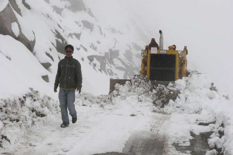
In 2015, the Parliamentary Standing Committee on defence stated that the Indian Army will take a day to reach Tawang whereas China can have her forces stationed there in two-three hours. It takes 18 hours from Guwahati in Assam to reach Tawang by road. Guwahati is the nearest major city. In addition to this, weather is an issue. There are torrential rains, landslides, waterfalls across the roads, washed away slopes and fog which deteriorates visibility.
In his statement to the Parliament’s Standing Committee on Defence, the then Indian vice chief of army staff Lieutenant General D. Anbu (2018-19) had underscored that the sanctioned budget for infrastructure development was running massively short for 2018-19. He pointed out to the “large number of Chinese strategic roads and infrastructural development along the northern borders”.
While Indian connectivity infrastructure plan is 20 years old, the Chinese have been understood to begin the construction of roads in the Himalayas as early as 1950. Analysts believe that Beijing needed roads and rails to assert control over Tibet.
Roads which link Xinjiang, Qinghai, Sichuan and Yunnan with Tibet facilitate the transport of troops to Tibet. China’s concrete infrastructure in LAC and Tibet Autonomous Region (TAR) adds to the country’s enhanced military capability.
In 2015, a joint statement from the People’s Liberation Army Air Force (PLAAF) and the Civil Aviation Administration of China (CAAC) mandated that civil-military integration would include joint maintenance of airport support facilities, joint flight safety support and joint airport management.
Notably, the Lhasa Gonggar Airport in Tibet and Sunan Shuofang International Airport in Wuxi in Jiangsu province were the first two pilot airports to implement such integration concepts in the second half of 2015.
The passenger volume at Gonggar Airport, the largest airport in the TAR, exceeded two million in 2013, and three million in 2016. TAR presently has 10 airlines operating a total of 81 routes. It was estimated that the airport saw the arrival of 4.3 million passengers by the end of 2018. On 9 June 2018, the CAAC and the TAR government announced that Tibet would soon have three new airports.
On rail connectivity, in September 2018, China Railway’s 11th Bureau successfully laid the first group of ballasts for the Gonggao station, a new station in the single-track ‘Lalin’ railway line, Sichuan-Tibet railway—a key project of the National 13th Five-Year Plan. Upon completion, it will become another railway artery connecting TAR with the mainland.
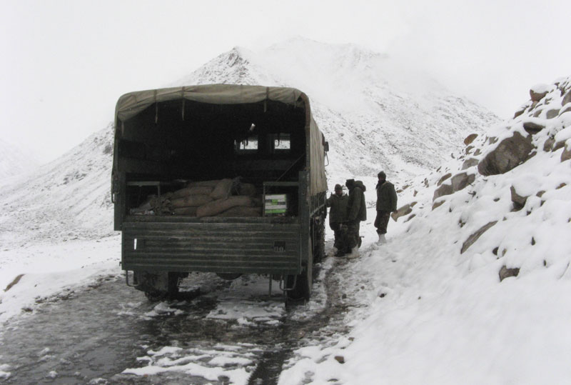
According to Lt Gen. Vinod Bhatia (retd), “Ladakh is connected by two major passes, Zoji la which remains open for approximate five months a year and Rohtang which remains open for even a lesser duration. This limited period of road days available is just about adequate to meet the ever-increasing material demands of the people of Ladakh and the army for their sustenance during the winters.”
In one of his pieces for FORCE, he explained that “The Old Tibet road is the single road axis leading to Puh from Shimla in Himachal Pradesh. This Axis is prone to major disruptions during monsoons and closes in part during the winters. Similarly, the roads leading to Harsil, Joshimath, and Tawaghat are no better and no closer to the LAC. The Uttarakhand floods of June 2013 are a stark reminder of the state of road connectivity and susceptibility to weather. Sikkim, too, remains connected from Siliguri with a single road axis prone to disruptions during monsoons and winters. The 319 km road from Tezpur to Tawang remains in a poor state and takes over 10 to 12 hours.”
In the Past
Till now, almost all efforts at building infrastructure along the LAC have been hamstrung because of poor technology, dithering political will, and dearth of funds. The China Study Group (CSG) under Prime Minister Atal Behari Vajpayee had identified 73 strategic road links in 2001, which would connect the frontier areas.
Ten years later in December 2011, the then defence minister A.K. Antony announced to the Parliament that only 13 of the 73 roads were complete. In 2017, in the middle of the Doklam standoff, the then minister of state (MoS) for defence, Subhash Bhamre, while responding to a question in the Parliament, said that “73 Indo-China Border Roads along Northern Borders are approved for construction. Out of this 27 roads have been completed and balance roads are planned for completion by December 2022.”
The minister further added that the delay in the construction of these projects is “due to delay in forest/wildlife/environment clearance, hard rock stretches, limited working season, delay in land acquisitions, difficulties in availability of construction material, and damage due to natural disasters such as flash flood.”
Current 15-year Infrastructure Building Plan
The construction of roads seemed to have fast-tracked after 2017’s Doklam standoff in a bid to up the country’s defence preparedness. A tri-junction point between India, China and Bhutan, Doklam is an area with a plateau and a valley, lying between China’s Chumbi Valley to the north, Bhutan’s Ha Valley to the east and India’s Sikkim state to the west. It has been depicted as part of Bhutan in the Bhutanese maps since 1961, but China also claims it.
The BRO has constructed an alternative road, previously a mule track, which goes from Bheem base to Doka la making it easier for the Indian troops to enter the Doklam Valley near Sikkim. The road was completed in 2018.
In addition to this, the BRO is planning to construct another motorable road on the Flag Hill-Dokala route by March 2021. Currently, Doka la is connected to India only through ‘Tri junction-Bheem base-Dokala’ route.
BRO on 23 May 2020 also completed the 50m Tawang Chu bridge and 45m Sukha bridge in Tawang and West Kameng districts respectively. The bridges will allow faster civilian and military movement near India-Tibet border.
According to media reports, the BRO has constructed 75 per cent of the entire length of strategic roads along the China border assigned to it. The same report citing government sources stated that the aim is to finish 11 more roads by the end of this year located in Uttarakhand, Arunachal Pradesh and Ladakh. Nine more such roads are expected to be built by March 2021.
The BRO has set a target to complete 61 of the 73 India-China Border Roads (ICBRs). The total length of 73 roads measure 4,643km. Apart from the 61 roads being built by BRO, the Central Public Works Department (CPWD) is currently engaged in the construction of 12 strategic roads along the Chinese border. Some of the finished roads include the stretch connecting Sasoma and Saseria in the Ladakh sector, the Ghatibagarh-Lipulekh road in the Mansarovar sector, Gunji-Kutti-Jollingkong road in the Uttarakhand sector, Doka la in the Sikkim sector, the Balipara-Charduar-Tawang road in the Tawang sector and the Damping-Yangtze in the Arunachal sector.
The BRO is also constructing 125 strategic bridges in different sectors of the LAC. In total, the BRO is constructing 410 bridges of strategic importance for stronger connectivity to LAC from Ladakh to Arunachal. Arunachal has the maximum number of bridges—144 out of 410— owing to its rivers and problems of monsoon.
Sino-India Skirmish & Standoff
Major sites of Chinese transgressions (2015 to 2019) on the LAC are: Pangong Tso, Trig Heights, Burtse, Dichu, Galwan River and Naku La. Here is a quick recap of wars, skirmishes, confrontations and standoff in the recent public memory:
- 9 May 2020 Naku La Face-off: The troops of the Indian Army and the Chinese People’s Liberation Army (PLA) were involved in incidents of face-off in North Sikkim on 9 May 2020. The incident took place at Naku La in North Sikkim, a pass in Sikkim at an altitude of more than 5,000 metres above the mean sea level. As many as 150 soldiers on both sides were involved in an aggressive confrontation that left at least 12 soldiers wounded. The intense stand-off was later resolved with the intervention of officers at the local Command level.
- 2017 Doklam Standoff: The 73-day long Doklam standoff between the Indian Army and the PLA over Chinese construction of a road in Doklam near a tri-junction border area, known as Donglang, or Donglang Caochang, in Chinese. Backing Bhutan, Indian troops had objected to the construction of road resulting in the stand-off. Doklam is located close to the Siliguri Corridor, which connects mainland India with its north-eastern region. The corridor is also called Chicken’s Neck.
- The 1986 Sumdorong Chu confrontation: This saw India moving tens of thousands of troops to the trouble spot under ‘Operation Falcon’. The confrontation was over the tiny Thangdrong grazing ground near Tawang, with India claiming that the watershed ran north of that meadow, and China claiming that it was to the south.
- The 1967 flagration: It comprised two incidents, in Nathu La and Cho La both in the eastern theatre.