

An air warrior’s first person account of the Kargil conflict
Air Marshal G.S. Bedi (retd)
It’s the silver jubilee year of the Kargil conflict and lot of water has flown through Jhelum since then. There have been insightful interventions, both educating and impressive, to bring out just about everything perceivable related to the conflict. Be it intelligence issues, tactical wisdom, inter service cooperation, role of air power and so on, more than enough has been documented, discussed, analysed and dissected.
While no discussion or analysis is really enough in learning about warfare, repetitive recall of statistics and the obvious tends to become boring. Having taken active part in the conflict, the endeavour here is to reflect on certain personal memories and thoughts that shaped the events during the conflict and had significant influence on the outcomes—in my opinion. The whole account is presented in first person and spares the reader any statistical data, hence is devoid of any references too.
The silver jubilee of Kargil is being celebrated, and rightly so because it was a hard win. All is well that ends well, and of course beyond any doubt it ended well. However, invariably in the euphoria of celebrating the end state, what gets ignored or overshadowed is how it all began. More often than not, pertinent lessons lie more so in how it all began than how it ended. So, to begin with, let’s see here how it all began.
The Story
It was a normal day in the month of May 1999 in Srinagar where I was posted as the Flight Commander of the resident 51 Squadron. Sometime in the afternoon, the Chief Operations Officer (COO) of the base called the squadron to Base Operations Centre for a briefing where the Colonel (General Staff) from the 15 Corps was present with maps rolled in a bundle to tell us something. He began by saying that there were reports of some intrusions in one of the sectors and while it would take a few days to clear them off, the squadron should standby for air support if necessary. There was no panic or concern in his voice, not that he was hiding it or putting up a show but because, as it became clear later, the extent of intrusions had actually not dawned on anyone yet. The Colonel left and so did we to get on with the next flying detail. It was business as usual. Very soon the reality started to show and when the action began it sucked everything around like a whirlwind.
Srinagar and its satellite base Awantipore became the major launch bases owing to their proximity to the area of action and 15 Corps was responsible for operations. The first hurdle was to identify the peaks where the intruders had dug in. The Ground Liaison Officer put in lot of hard work in conjunction with the staff at Corps and briefed the pilots on various peaks of interest, mostly naming them by their trigonometric heights above sea level in metres, like 4590, 5353, 5770 etc. The famous names like Tiger Hill, Tololing emerged somewhat later. These peaks looked magnificent even on the map and each one could be easily differentiated from the others in their surroundings.
While on the ground, it seemed like a very easy task to locate these peaks from the air. However, it was a different story altogether when one looked at them from 25,000 feet in the air. They all looked the same—one no different from the one next to it, hence with no way to mark them individually as expected. It took considerable effort, time and improvisation to identify the targets of interest. From hand-held video cameras to the laser designated pods of Mirage 2000, it took everything at the disposal of the Indian Air Force (IAF) to finally locate the targets precisely.
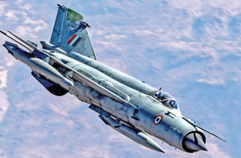
While the efforts to locate the targets were underway, the other challenge that surfaced was how to address these targets at such altitude with the initially inducted aircraft MiG 21/23/27 at the bases mentioned above. The firing solutions offered by these aircraft did not cater for release of weapons for a target located mid-air. To paraphrase this expression, invariably the legacy aircraft’s firing system caters to two kinds of heights, one its height above mean sea level—that is altitude to calculate the kinetics of its own and that of the weapon system, and the other its height above the ground where the target is located, to calculate the forward throw.
The problem here was that there was a third variable. The height of the aircraft above the ground where it’s flying and that above the target where the weapon impact is expected were different, rendering the integral firing solutions ineffective. Advanced aircraft with precision attack capabilities could overcome these limitations but they had not yet arrived on the scene. On the spot calculations of delivery parameters to suit the conditions in the war zone and improvisation to use handheld navigation devices to effect deliveries based on the freshly calculated forward throws, followed by trials at high altitude range close by started providing some clue. Air to ground weapon delivery after all is just science based on the laws of physics, the right application is the art of war. There is no doubt that the effect achieved by the Precision Guided Munitions (PGMs) delivered by Mirage 2000 and Jaguars had a much more devastating effect than the dumb bombs delivered by MiG 21/23/27 but the latter’s contribution cannot be completely wished away. They may not have busted many bunkers directly leading to the elimination of the enemy. The relentless round the clock delivery of arsenal, even in close vicinity of the targets, forced the intruders to stay inside their bunkers or keep their head down for prolonged periods, helping the ground forces’ advance to an extent. The campaign did prove the saying that quantity has a quality of its own. But it wasn’t that straight either, just when the pilots had settled down with new attack parameters, another evil raised its head—not necessarily unknown but definitely ignored.
Unfortunately, the presence of shoulder fired missiles at those peaks was somewhat ignored. The reason I say ignored is that even when a Canberra aircraft had landed at Srinagar with telltale signs of being hit by a Stinger missile, the attack patterns adopted by the fighter aircraft over the occupied peaks did not keep them outside their envelop, resulting in the loss of a MiG-21 and one Mi-17 to the missile fire, while a MiG-27 was lost owing to engine failure. Unfortunately, the pilots of both the fighter aircraft had to eject in enemy territory and were taken as prisoners of war (POW)—Sqn Ldr Ajay Ahuja sadly fell to the atrocities of his captors. Salute to the valiant air warrior and all those who made the supreme sacrifice to safeguard the honour of our motherland.
This tragic loss pushed the envelope upwards to keep the fighter aircraft safe from this threat, which meant that the lowest height that the aircraft should come to over an occupied peak would be in the region of two to three kilometres. Considering the average altitude of peaks as 4.5 kilometres, the lowest an aircraft could touch on altimeter would be about seven kilometres. Taking into account the safe pull out, almost astronomical commencement height for a safe dive attack, and the accuracy achieved thereof, made them impractical. The problem with accuracy was not only that you would miss the target and waste a bomb, it was much more serious. On plain ground if the firing error is, say 50 metres, then the weapon misses the target by just 50 metres. In a warlike situation where the collateral damage is really not an issue, it can be overlooked.
However, the rules of the game change completely while firing on targets over steep hills, with one’s own troops in close proximity. In this case, since the attacks had to be undertaken from our side of the territory, if the bomb undershot it might land up on our own troops scaling the mountain face. On the other hand, if it overshot, it would cross the Line of Control (LoC), which clearly was not an option. Therefore, if reasonable accuracy was to be achieved by the MiG class, the firing height had to be lower, which attracted targeting by shoulder fired missiles. But a way had to be found and the decision was taken to carry out night attacks, which kindles another fond memory.
One of the squadrons to induct in Srinagar was 17 Sqn, then commanded by Wing Commander B.S. Dhanoa, later chief of the air staff. Sqn Ldr Ajay Ahuja was from the same squadron. As the orders were passed to switch to night attacks, a lot of professional debates started over their feasibility and efficacy. To present it linearly, flying itself is a challenge, flying in hills is a bigger challenge, and carrying out attacks in hills is a different game altogether. In another dimension, flying itself is a challenge, flying at night is a bigger challenge, and carrying out night attacks is a different game altogether. Deducing from the above two statements, carrying out night attacks in the hills was certainly not a case of plug and play. The IAF wouldn’t have liked to lose any aircraft to complexities of execution. Now, maintaining one’s bearings and situational awareness in hills takes more than a compass. The bends in the valleys and twisting ridgelines can easily confuse a pilot with respect to where the aircraft is heading. Therefore, the positional awareness in such areas has to be supplemented by general awareness as well.
As the flight commander of the resident squadron, I clearly remember training young pilots on this aspect by corelating the appearance of certain prominent features with the clock codes to make out general direction, in addition to the compass or any other direction indicating device. For example, while coming back from Kargil or Dras sector towards Srinagar, if the clock code of Nanga Parbat was anything less than 1.30, you would be heading into danger and needed to change course immediately to get it beyond 2 o’clock. It was one of the many tips that experience taught you. To draw an analogy, as the resident squadron in Srinagar we were like locals in the area who knew a little more than the tourists who landed with a map there. This local wisdom was acknowledged by the Commanding Officer of 17 Squadron, Wing Commander Dhanoa, who asked me to fly a night familiarisation sortie with him in a MiG 21 trainer. Frankly, I flew that sortie like any other dual sortie, one amongst many that I had flown with my own young pilots, dutifully telling him the nuisances of flying in that area at night, little realising that this would be etched in my memory forever. My second pilot in that sortie, later as Air Chief Marshal Dhanoa, very fondly recalled that experience in a television interview. His maturity and approach of doing things in the right way have always been a lesson in aviation and an inspiration in life.
You must be logged in to view this content.