

India should opt for a pre-emptive ‘kill-chain’ against Pakistan Army’s TNWs
Prasun K. Sengupta
Soon after May 1998, the chances of an all-out conventional war breaking out between declared nuclear weapons-armed states like India and Pakistan across the 2,175km-long International Boundary (IB) have become nil, and since mid-1999 (following Op Vijay and Op Safed Sagar) has been replaced by greater prospects of limited but high-intensity wars being fought along both the Line of Control (LC) and that part of the IB that Pakistan refers to as the Working Boundary (WB).
India’s State of Jammu & Kashmir has 734km of LC running through Jammu, Kashmir and Ladakh regions from Kargil to Malu (Akhnoor) in Jammu district, while it has 190km of IB from Malu to the Punjab belt running through Jammu, Samba and Kathua districts. The WB, spanning 202km and including the Chicken’s Neck area, lies in Jammu Division between Boundary Pillar 19 and Sangam i.e. between Jammu and Sialkot, which was part of the erstwhile princely state of J&K. It is this stretch that Pakistan refers to it as the WB, since it maintains that the border agreement (the so-called standstill agreement) was inked between the princely state of J&K and Pakistan, and not between India and Pakistan. Given the fact that India maintains a near-foolproof anti-infiltration grid along the LC, Pakistan has since mid-2013 focussed its terrorist infiltration efforts (via underground tunnels dug throughout the Chicken’s Neck area) along the WB.
Chicken’s Neck is the name given to the territory lying between the two branches of the River Chenab and it is a dagger-shaped salient in J&K that allows the Pakistan Army (PA) an easy access to the bridge at Akhnoor in Jammu, as well as to the Chhamb-Jaurian sector. Measuring about 170sqkm, it is bound by the River Chenab in the west, and by the River Chandra Bhaga, or Ghag Nala in the east. Ferries in Saidpur, Gondal, Majwal and Gangwal areas connect it with the Sialkot sector.
Being an open area in the plains, it is excellent for the conduct of swift, offensive manoeuvre warfare by the Indian Army. However, for Pakistan, this area is indefensible by conventional means, as it is surrounded by India from three sides and back in December 1971, was captured by India within a 48-hour period. Consequently, if the IA were to opt for a high-tempo but limited land campaign (under its Cold Start doctrine), with the objective being a piece of Pakistani real-estate stretching all the way out Chhamb, then the only available option for the PA is to exercise its right to self-defence by using tactical nuclear weapons (TNW) against invading IA formations within the Chicken’s Neck salient, i.e. inside sovereign Pakistani territory.
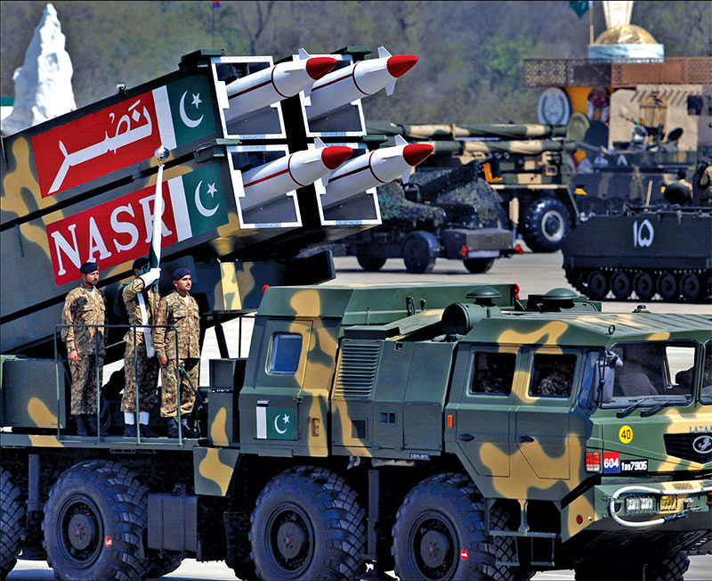
It is for this reason that the PA between 2012 and 2015 constructed a purpose-built cantonment at Pasrur (southeast of Sialkot) for housing its 18 Hatf-9/Nasr multi-barrel rocket launchers (MBRL), each of which can salvo-fire four 300mm WS-32 rockets. The WS-32, developed by the Sichuan Academy of Aerospace Technology (SCAAT, formerly known as Base 062 at Chengdu), and now part of China Aerospace Science & Technology Corp (CASC), is 7.5 metres in length, can carry a 170kg TNW with a yield of 3 Kilotons out to a distance of up to 150km, and has a 30-metre circular error probable.
In such a scenario, where India will find herself extremely hard-put to justify a second-strike retaliation with nuclear weapons, the only available option then — in order to retain moral ascendancy — will be to resort to a doctrine of pre-emptive but conventional first-strike against the PA’s stockpile of deployed TNWs both at Pasrur and within the Chicken’s Neck area. And to achieve such a capability, the IA will require two critical tools:
1) A space-based early-warning capability to locate and destroy the 8 x 8 transporter-erector-launcher (TEL) vehicles carrying the Hatf-9/Nasr MBRLs while they are on their pre-surveyed launch-pads; and
2) at least six Regiments of ground-based missile-based interceptors.
To fulfill the first requirement, the state-owned Indian Space Research Organisation (ISRO) has since 2012 been working on the development of tiny, inexpensive overhead recce ‘micro-satellites’ that can be launched in clusters within short notice, and which can stay in low-Earth orbit for just a few months. Such ‘micro-satellites’ will be tasked for both the detection of salvoes of short-range ballistic missiles and MBRL-launched rockets, as well as the localisation of the deployed MBRL-carrying TELs on the battlefield.
Together, they will provide persistent, uninterrupted coverage of a pre-defined tactical theatre, since the key to detecting hostile TNW launch preparations and related vehicular movements on the ground is the near-constant presence of satellites that can see through clouds, rain, snow, foliage and camouflage. The first prototype of such an imaging satellite, called Microsat-R, was launched on January 24 this year by a modified PSLV launch vehicle with just dual strap-on motors in order to demonstrate the usability of the launcher’s fourth stage (known as PSLV-DL) for a period of either six months or a year after its principal satellite payloads had been ejected into orbit.
What this means is that the PSLV-DL can be used for deploying two separate clusters of ‘micro-satellites’ during different timeframes—one being for imaging purposes and the other for detection of hostile rockets in their boost-phase. The backpack-sized Microsat-R was placed in orbit at an altitude of 274km thirteen-and-a-half minutes after liftoff, following which its antenna and solar panels were unfurled.
For meeting the second requirement, India’s Defence R & D Organisation (DRDO), under a joint R&D programme similar to the one undertaken for the Barak-8 SAM’s co-development, has been authorised to work with Israel Aerospace Industries and RAFAEL Advanced Defence Systems for developing an India-specific variant of Israel’s Iron Dome missile-based interceptor system. Essentially, this will comprise three fundamental land-mobile (motorised) elements: a detection and tracking radar (this being the DRDO-developed Arudhra S-band active phased-array radar), a battle management system (BMC), and a missile firing unit (MFU) housing up to 16 Tamir-type vertically-launched interceptor missiles. The missile will feature several steering fins for high manoeuvrability and will be equipped with electro-optic sensors.