

Phase II of the coastal surveillance network likely to completed by year end
Atul Kumar | New Delhi
Almost a decade after the 26/11 attack, the Indian Navy and Indian Coast Guard (ICG) took several initiatives to strengthen the coastal security and surveillance network around 7,516.6-km-long coastline traversing nine states and four union territories of India in pursuance of the ministry of defence-approved coastal surveillance network (CSN) project.
Envisaged in two phases, the CSN comprises a chain of radars along with other sensors to provide 24x7, effective and actionable intelligence along the Indian coastline and territorial waters.
The CSN features a series of exclusive surveillance gadgets such as Frequency Diversity Radar, Electro-Optic sensors having Charge Coupled Device (CCD) day camera, Low Light TV (LLTV) night camera, Long-Range thermal imagers, an Automatic Identification System (AIS), a distress alert transmission system (DATS) and meteorological sensors.
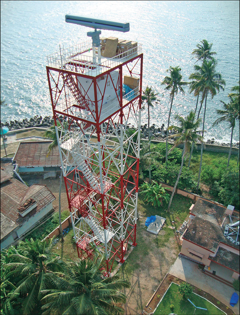
In Phase 1 of the CSN project, a total of 46 coastal surveillance radars and electro-optic sensors have been established — 36 on the mainland, six in the Lakshadweep islands and four in the Andaman & Nicobar Islands. Thirty eight additional radar stations with eight separate mobile surveillance systems worth around Rs 800 crore are being installed under CSN Phase 2. These will be integrated with two vessel traffic management system (VTMS) centres at the Gulf of Kutch and Gulf of Khambhat.
The whole system is being connected to NC3I (National Command Control Communication Intelligence) which operates under Information Management and Analysis Centre (IMAC), Gurugram. Bharat Electronics Limited’s (BEL) advance ‘data fusion’ method will help integrate this entire information mechanism. The information collected by the sensors will pass through a robust hierarchical network architecture that connects ICG’s district and regional headquarters to its headquarters at New Delhi. Data received from this network will be further supplemented with the AIS data and VTMS of the major ports, Fishing Vessels Monitoring System, Long Range Identification and Tracking (LRIT) and N3I of Indian Navy.
The Phase 2 is to provide effective and gapless electronic surveillance of Indian coastline. It is being executed by state-owned BEL, which also completed the setup and integration of Phase 1. BEL has installed 12 remote operating stations that control all 46 sensors under Phase 1.
The coastal surveillance radar is the key element of the CSN system. It is capable of detecting sub-20-metre vessels such as dinghies and fishing boats in heavy sea traffic in all-weather conditions.
Coastal surveillance radars basically operate in X-band which are very precise and give good target resolution. The CSR can easily be adapted to S-band from X-band during unfavourable weather conditions. In S-band mode, the radar’s range is slightly affected. Frequency diversity is used in the X-band radar to de-correlate sea clutter, eliminate small target fluctuations and reduce multipath (lobing) effects. This mechanism improves detection or scan of small targets at all ranges.
AIS is another key component of the CSN project which helps to receive signals from VHF transponders installed on ships or vessels and transmits the information to an authorised control station via communication satellites. AIS helps ICGs locate boats or other suspected vessels during a security check. The installation of the system is necessary for all boats over 300 tonnes. The system also supports naval radar through VHF transponder signals. The correlation of the AIS network with key radar systems significantly improved the ocean traffic management and cut back the workload on maritime security organisations.
CSN also features a distress alert transmission system (DATS) which is developed by ISRO. This system includes emergency buttons such as cyclone alert, hostage alert, fire alert, terrorists’ movement alert by which boat’s crew can intimate the ICG in hostile situations.
CSN Phase I incorporated some Israeli-made sensors, cameras and radars, which possibly had been supplied by IAI’s Elta, while US’ technology major Raytheon had supplied customised software to BEL. The Raytheon software helped to attach sieves to spot threats from boats in the ocean by data fusion and link mechanism. The software also scans the condition of the remote systems featuring an alarm system for alerting control station when a boat invades a designated area at sea known as sensitive zone.
You must be logged in to view this content.