

The Eyes Have It
The wealth of information captured by satellites orbiting above earth’s surface has revolutionised our capacity to comprehend and respond to critical issues that support a wide range of scientific and operational activities related to infrastructure mapping, crop monitoring, water resources assessments, urban monitoring, land use and land cover mapping, natural resources monitoring and vegetation assessments.
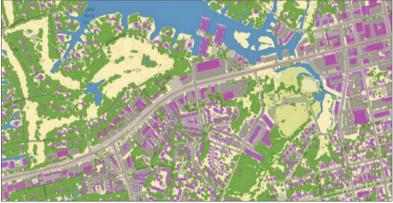
Machine Learning Image Classification example – Green = trees and vegetation, Blue =water, Grey = streets and concrete, Tan = exposed earth (soil). (Source: mapasyst.extension.org)
However, despite the invaluable insights that satellite imagery offers, the manual analysis of the vast and ever-expanding datasets it generates remains a formidable challenge. Remote sensing systems are built to take advantage of various parts of the electromagnetic spectrum and atmospheric windows to observe different targets. Passive sensors detect natural energy emitted or reflected by the earth such as optical sensors that capture sunlight reflection whereas active sensors emit energy and measure the reflected or backscattered signals.
With satellite proliferation, camera technology enhancement, improved data storage and transfer competencies, there is an exponential increase in the amount of data being produced from satellites. A wide variety of applications and enormous amount of satellite data growing exponentially has critical demands in speedup, cost cutting and automation in its processing while maintaining accuracy. Combination of spatial analysis, image analysis and artificial intelligence will function as one powerful system that can handle massive datasets at local and global scales.
Remote Sensing
Remote sensing is a technology that enables data collection without direct contact with the subject being investigated, utilising sensors to measure or detect various types of energy such as electromagnetic radiation and acoustic signals emitted, reflected or scattered by the object being analysed. The systematic data acquisition, processing, archiving and dissemination of satellite data is a fundamental task performed by most satellite ground receiving stations across the world.
Any remote sensing data acquisition system primarily consists of selection of three major aspects, namely platform (spaceborne/ airborne), remote sensing system (optical/ Synthetic Aperture Radar) and sensors fitted on an aerial platform (data from any specific satellite/ airborne/ UAV sensor). Remotely sensed data are prone to several systematic and random effects that combine to degrade the quality of satellite imagery received on the ground. Image restoration procedures are therefore required to rectify these degradation effects. In most cases, ground receiving stations focus their attention on two fundamental image pre-processing procedures, known as geometric and radiometric rectification.
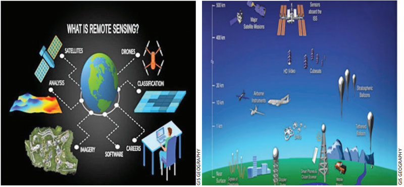
Major Remote Sensing Technologies and their Altitudes
Geometric rectification aims to register satellite imagery within a specific geographic reference system and to eliminate the systematic distortions resulting from image displacements by applying systematic high order transformations. Radiometric rectification seeks to eliminate or minimise distortions in the values recorded for image pixels due to atmospheric effects, striping, random noise and scan line dropouts. In general, machine learning (ML) comprises a set of algorithms or models that have data (training data) specific to an application, that is, which can be used for training and inference to be drawn from observed patterns (features trends) obtained and image resolution.
Subscribe To Force
Fuel Fearless Journalism with Your Yearly Subscription
SUBSCRIBE NOW
We don’t tell you how to do your job…
But we put the environment in which you do your job in perspective, so that when you step out you do so with the complete picture.


 VIDEO
VIDEO