

Limitless Opportunities
Until now the Indian Space Research Organisation (ISRO) under the department of space has undertaken 105 Spacecraft Mission, 75 launch missions including a scramjet technical demonstration, launched 10 student satellites, two re-entry missions and 297 foreign satellites of 33 countries.
The ISRO’s INSAT (Indian National Satellite system) is the largest constellation of communication satellite in Asia-Pacific with 15 operation satellite namely INSAT-3A, 3C, 4A, 4B, 4CR and GSAT-6, 7, 8, 9, 10, 12, 14, 15, 16 and 18. The INSAT constellation provides more than 200 ‘C’ Band and ‘Ku’ Band transponders for services pertaining to disaster warning, search and rescue, weather forecasting, societal applications, news gathering, tele-communication and television, broadcasting.
Major Milestones
Earth Observation Satellites: Earth’s Remote Sensing Satellites observe and record various parameters of earth, they are somewhat like a spy satellite but used for non-military purposes. These satellites have diversified spatial, spectral and temporal resolution and provide data to meet different user requirements for both global and domestic requirements for the purpose of agriculture, water resources, urban planning, rural development, mineral prospecting, environment, forestry, ocean resources and disaster management.
India also has 13 operational remote sensing satellites which is one of the largest constellation in its class and involve satellites RESOURCESAT-1, 2, 2A CARTOSAT-1, 2, 2A, 2B, RISAT-1 and 2, OCEANSAT-2, Megha-Tropiques, SARAL and SCATSAT-1 and 4. In Geostationary orbit we have INSAT-3D, Kalpana & INSAT3A, and INSAT-3DR.
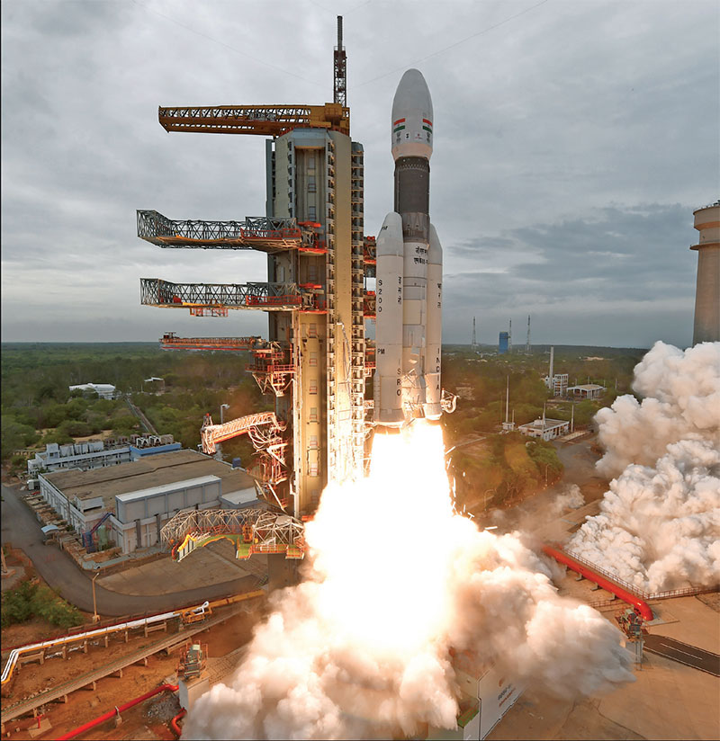
GSLV Mk III rocket, carrying Chandrayaan-2, lifts off
Experimental Satellites: ISRO also has many experimental satellites that it launched to undertake research in the field of remote sensing, atmospheric studies, payload development, orbit controls, recovery technology such as CARTOSAT series including INS-1C, INS-1B, INS-1A, a student satellite — YOUTHSAT, APPLE — an experimental communication satellite, Rohini Satellite and Aryabhata.
Satellite Based Navigation System: ISRO is working jointly with Airport Authority of India to develop the Global Positioning System (GPS)-aided Geo Augmented Navigation (GAGAN) system. GAGAN will provide accurate and timely satellite-based navigation system for air traffic management for civil aviation application through GSAT-8 and GSAT-10 satellites. GAGAN will also be interoperable with other international Satellite-based Augmentation System (SBAS) and will provide safe and seamless navigation across regional boundaries.
The Indian Regional Navigation Satellite System: NavIC i.e., Navigation through Indian Constellation is an independent indigenous satellite-based regional positioning system meant for the defence services and for critical national applications. NavIC is meant to provide two types of services — Standard Positioning Services and Restricted Services. ISRO has built total of nine satellites in IRNSS series of which eight are in orbit. Three of these satellites are in Geo-synchronous orbit at 29-degree inclination to equatorial plane. However, the NavIC has been facing considerable problem from failure of on-board Rudibium atomic clocks imported from Europe. Accurate calculation of position becomes difficult when time signal is erratic or missing. The satellites operate in L5 and S Band. However, the same band is also used in communication devices like Bluetooth, LTE and Wireless Fidelity (wifi) and the experts are apprehensive that the NavIC may interfere with them. This is likely to affect NavIC receiver in proximity. User in India and 1,500 km from its borders can benefit from NavIC.
NavIC will help India enter a group of select countries having their own navigation system, a bit akin to United States’ GPS, which has a 24-satellite constellation. The Russian system is called GLONASS, the European Union’s Galileo and the Chinese are developing their BeiDou navigation satellite system. The system has cost ISRO Rs 1,400 crore and will aid in terrestrial, aerial, and marine navigation, fleet management, vehicle tracking, providing geodetic data, mapping, visual and voice navigation for drivers. The NavIC is superior to GPS as it has dual band over single band of GPS and will prevent interference, frequency delay and disturbances giving higher accuracy. ISRO is in talks with two major chipmakers for supply of NavIC chips for Indian smartphones; with US-based chipmaker Qualcomm and also with Singapore based Broadcom. ISRO’s commercial arm has already acquired Multi Chip Module (MCM) from Taiwan based firm SkyTraQ. The MCM is based on 55nm technology to build NavIC messaging and Vehicle tracker units. The IAF is already in discussion with ISRO for fitting of NavIC navigation system in its aircraft.
AstroSat: This is ISRO’s first satellite dedicated to deep survey and study of the Universe and celestial bodies. It is capable of studying various celestial emissions in X-ray, optical and UV spectral bands simultaneously; a capability which even NASA’s Hubble telescope doesn’t have. It enables the simultaneous multi-wavelength observations of various astronomical objects with a single satellite. Launched on 28 September 2015, the minimum useful life of the AstroSat mission is expected to be for five years.
Mangalyaan: India created ripples in the world’s space agencies with the success of its Mars Orbiter Mission, named ‘Mangalyaan’, in its very first attempt. The Mangalyaan, launched on 5 September 2013, was India’s first inter-planetary mission. The success of the mission made India only the fourth country after the US, Russia and European Space Agency to have achieved this feat; beating even China and many other first world nations. The Mars probe was launched using India’s workhorse PSLV. The MOM carried five scientific instruments. It is the least expensive Mars mission till date costing about Rs 450 crore. The primary objective of the mission was to develop the technologies required for designing, planning, management and operations of an interplanetary mission.
Chandrayan: India had successfully launched its first lunar mission ‘Chandrayan-1’ on 22 October 2008 with 11 scientific instruments of the US, UK, Germany, Sweden and Bulgaria. The spacecraft orbited 100 km from the surface of the moon and carried out chemical, mineralogical and photo geologic mapping of the Moon. Chandrayan-1 was the first one to discover presence of water in Moon’s crater.
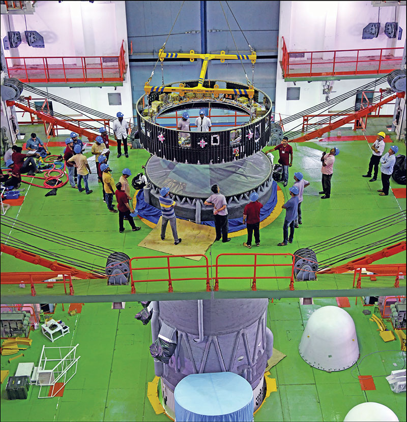
Hoisting of the equipment bay of GSLV Mk III M1 vehicle during integration
‘Chandrayan-2’, carrying 13 payloads, was launched on 22 July 2019 after quickly overcoming an initial glitch. The lunar mission to Moon’s South Polar Region was designed to improve the understanding for future space expeditions. The mission’s objectives were to trace the history of moon and study water molecules in the landing region. The mission was also a test bed for technologies required for deep-space mission. The mission included a lander ‘Vikram’, with three payloads, designed to soft land on the moon surface; a rover ‘Pragyan’ carrying two payloads, for exploration and experimentation, and an orbiter with eight payloads, to relay information to Earth station.
Subscribe To Force
Fuel Fearless Journalism with Your Yearly Subscription
SUBSCRIBE NOW
We don’t tell you how to do your job…
But we put the environment in which you do your job in perspective, so that when you step out you do so with the complete picture.


 VIDEO
VIDEO